Skip to content
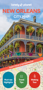

New Orleans City Map
Overview
Experience your dream trip with Lonely Planet's New Orleans City Map, the ultimate travel tool with a full colour, easy-fold waterproof map and handy slipcase. Discover must-see highlights from hearing jazz music on Frenchmen Street to strolling through Audubon Park; find top travel information and tips; and get to where you want to go - your way.
What's Inside
Experience your dream trip with Lonely Planet's New Orleans City Map, the ultimate travel tool to help you plan and navigate your way around amazing local sights, landmarks and attractions.
Cycle the historic 2.6 mile Lafitte Greenway, breathe in the fresh air in shady Audubon Park, explore three centuries of Louisiana history at the Cabildo, and decide where you want to go next and what you want to see in each of the city's exciting neighbourhoods.
Inside Lonely Planet's New Orleans City Map:
- Full colour map in a durable easy-fold format
- Waterproof and packaged in a handy slipcase
- Alphanumeric grid to find points of interest easily
- Public transport explained to help you get around
- Top picks of must-see highlights including Frenchmen Street, National WWII Museum, and St Louis Cathedral
- Essential travel tips and nuts and bolts information on money, food & drink, festivals and events
- Beautiful photography and bonus zoomed-in map of Mid-City, Esplanade Ridge & Bayou St John
- Covers: French Quarter; Garden District; Gretna; Irish Channel; Lower Garden District; Mid-City; Riverbend; St Roch; The Tremé; Uptown; Warehouse District
Get ready for your next adventure with Lonely Planet's New Orleans City Map, the ultimate navigation tool to help you explore New Orleans' well-known attractions and best-kept secrets.
Product Details
- Size3.74" × 7.76"
- Publication dateAugust 1st, 2025
- LanguageEnglish
- Edition2nd
- Print length2 pages
- ISBN9781787015999
- AuthorsPlanet, Lonely
Buy 2 & Get 10% off
When you add a second book from our expert recommendations, you’ll unlock 10% off your full order. Discount will be automatically applied. Exclusions apply.


You May Also Like
Enhance your travel research with these popular titles that are handpicked to pair well together!